|
|
| |
CLC2018 SUPPORT PACKAGE
AND OTHER ANTECEDENTS
|
|
| |
CLC2018 Support Package
| |
|
CLC2018 Support Package is a software tool for European CLC2018 change
detection and mapping. It is a significantly modified and improved
version of the CLC2012 Support Package.
CLC2018 software is a set of standalone applications developed with
Embarcadero Delphi 10 and TatukGIS Developer Kernel 11.
Thus user does not need to purchase, install and tune any other software
to carry out CLC2018 change mapping.
Commonly a GIS software is designed primarily for viewing GIS databases with
tools for creating maps, menus for handling databases and graphical editing
tools. If software has editing possibilities too, these are general tools,
not specialized for individual tasks. On the contrary, CLC2018 Support
Package is a specialized, task oriented software, that significantly
facilitates updating, change detection and mapping, quality control and
correction of CORINE land cover databases by means of computer-assisted
visual photointerpretation. Consequently, this software is not
applicable for creating, viewing or editing GIS databases in general.
For theese purposes one can use any common commercial (e.g. ESRI ArcGIS)
or free (e.g. QGIS) software.
CLC2018 Support Package was downloadable from Eionet Forum homepage.
Schedule of the development
- 23.12.2016 Signature of contract between BFKH and the author.
- 01.08.2017 Starting beta test with the main functions.
- 01.10.2017 Starting final test with the fully operational software.
- 16.10.2017 Starting deployment of the software.
About the software
The CLC2018 software has been
developed for the Government Office of the Capital City Budapest (BFKH),
legal successor of the Institute of Geodesy, Cartography and Remote
Sensing (FÖMI).
BFKH as consortium member of European Topic Centre Urban, Land and
Soil Systems (ETC/ULS) provides assistance for the implementation
of European CLC2018 project managed by the European Environment Agency
(EEA) within the framework of
COPERNICUS Earth Observation Programme.
CLC2018 software development is funded under Service Contract
No 3436/R0-COPERNICUS/EEA.56655 between EEA and ETC/ULS.
New or modified features
- The 3 band IMG satellite images contain RGB color channels in the reverse
order compared to other common raster image formats. CLC2018 software
automatically changes R and B bands for the conventional colouring, but
in the prior version the Add raster layer window showed
1, 2, 3 band number – as in case of other image formats.
In the current version the software shows the true 3, 2, 1 band numbers,
bat beside them write a red "BGR!" warning.
- Before saving the Change layer program checks the number of change
polygons to prevent accidental data loss, and sends a warning if this
number decreased compared to the previous saving.
- New alternative Progress colouring grid shows ready polygons almost
fully transparent.
- In the Default settings dialog user can check Permanent polygon mask,
and in this case – if the Polygon mask button is down – the mask appears
automatically around all newly selected polygons.
- If any colouring is on at the beginning of a temporary saving, program
automatically switches on that colouring after the saving.
- Multipart polygon warning message at polygon editing was improved.
- Operation of the Reshape tool simplified to avoid polygon editing errors.
This tool operates now only on the common border of two adjacent polygons.
- Operation improved by deleting change polygons, which was affected by
the subsequent editing of a revision polygon.
- It is not required to specify Map sheets grid background file at the
first start of the software.
|
|
CLC2018 registered users (32)
- Albania
– National Environmental Agency
- Austria
– Umweltbundesamt GmbH
- Belgium
– GIM Smart Geo Insights
- Bulgaria
– Space Research and Technology
Institute;
– Executive Environment Agency
- Croatia
– OIKON (Institute for Applied
Ecology Ltd.);
- Cyprus
– Cyprus University of Technology
- Czech Republic
– Gisat s.r.o.
– CENIA (Czech Environmental
Information Agency)
- Georgia
– GIS-Lab Ltd.
– Ministry of Environment Protection
and Agriculture of Georgia
- Greece
– Hellenic Cadastre
- Estonia
– Estonian Map Center
- Hungary
– Government Office of the
Capital City Budapest
- Iceland
– National Land Survey of Iceland
- Ireland
– Environmental Protection Agency
- Kosovo
– Kosovo Environmental Protection
Agency
- Lithuania
– SE GIS-Centras
- Luxenbourg
– Space4environment
- Malta
– Malta Environment and Planning
Authority
- Norway
– Norvegian Institute for Bioeconomy
- Poland
– Institute of Geodesy and
Cartography
- Portugal
– Directorate General of the Territory
- Romania
– Danube Delta National Institute
for Research & Development
- Serbia
– GILAB DOO Beograd
- Slovakia
– Slovak Environmental Agency
- Slovenia
– Geodetic Institute of Slovenia
- Spain
– National Reference Centre
on Land Cover
- Switzerland
– Swiss Federal Institute for Forest,
Snow and Landscape Research
- Sweden
– Lantmateriet
- Turkey
– Ministry of Forest and Water Affairs
- United Kingdom
– Specto Natura Limited

|
|
CLC2012 Support Package
| |
|
CLC2012 Support Package is a significantly modified and improved version
of the CLC2000 and CLC2006 Support Packages. The CLC2012 software has been
developed for Remote Sensing Centre of Hungarian Institute of Geodesy,
Cartography and Remote Sensing (FÖMI), consortium member of European
Topic Centre Spatial Information and Analysis (ETC–SIA) in order to
help implementation of the European CLC2012 project managed by the
European Environment Agency (EEA) within the framework of GMES Initial
Operations (GIO).
CLC2012 Support Package is a set of standalone applications developed with
Embarcadero Delphi XE2 and TatukGIS Developer Kernel.
Thus user does not need to purchase, install and tune any other software
to carry out CLC2012 change mapping.
Commonly a GIS software is designed primarily for viewing GIS databases with
tools for creating maps, menus for handling databases and graphical editing
tools. If software has editing possibilities too, these are general tools,
not specialized for individual tasks. On the contrary, CLC2012 Support
Package is a specialized, task oriented software tool, that significantly
facilitates updating, change detection and mapping, quality control and
correction of CORINE land cover databases by means of computer-assisted
visual photointerpretation. Consequently, this software is not
applicable for creating, viewing or editing GIS databases in general.
For theese purposes one can use any common commercial (e.g. ESRI ArcGIS)
or free (e.g. Quantum GIS) software.
CLC2012 Support Package was downloadable from Eionet Forum homepage.
Schedule of the development
- 10.11.2011 Preliminary study about the ways of the software development.
- 22.02.2012 Signature of contract between ETC–SIA consortium and EEA.
- 26.03.2012 Signature of contract between FÖMI and the author.
- 01.08.2012 Starting beta test with the main functions.
- 01.11.2012 Starting final test with the fully operational software.
- 14.01.2013 Starting software deployment for interested countries and institutions.
- 15.07.2013 Signature of contract for revised and enlarged version between FÖMI and the author.
- 26.09.2012 Starting beta test with the revised and enlarged version.
- 20.11.2013 Starting deployment of the revised and enlarged version 3.1.
Limits of the ArcView software
CLC2006 Support Package runs on the base of the ESRI ArcView software. Last version of ArcView (3.3) was released in May 2002 and since April 2005 ESRI has provided only limited support for this product. There is no guarantee that software runs under future Windows operating system versions without any problem. Institutions established lately or new users usually do not have licenses of this software. Additionally, in ArcView there is no possibility to use on-the-fly coordinate reference system transformations, and web mapping services. Due to these arguments it is reasonable to find a new basis for the further development of the CLC Support Package.
Financial considerations
The CLC2000 software was free for participating countries on the condition that it is used solely in the implementation of the CLC2000 project. Conversely, CLC2006 software was a commercial product, customers therefore could use software licenses without any time or project limitations. In case of CLC2012 Support Package the decision was to make it available for participating countries free of charge and at the same time make sure that no additional costs (of purchasing the background commercial GIS) put burden on participants. Therefore two options for development were left: either using open source software as background for the development, or creating standalone executable software with a royalty free GIS object library.
Creating standalone executable
Royalty free means that if the developer purchases the object library, all software products, created with help of this library, can be retailed or sold without any further payment to the manufacturer of the object library. The standalone executable can be developed in any common programming language (Delphi, C++Builder, .NET, etc.), that can handle Windows Visual Component Library (VCL) objects.
Benefits:
- Developer does not need to conform to the unalterable facilities and restrictions of the background software.
- The user interface and program features can be optimized for the work, without unnecessary tools and controls.
- User does not need to purchase, install and tune any other software.
User feedbacks
After the completion of the CLC2012 project Technical Support sent a short questionnaire to the participant institutes about the software.
Suggestions for further development of the software are also collected.
The summarized results are here.
- Number of registered countries: 28
- Number of registered institutes: 34
- Number of responded institutes: 22 out of 34 (65%)
- Total number of answers (counting separately responded users): 29
Which of software components you have used in operational way?
- InterChange and InterCheck: 23 (80%)
- InterChange only: 5 (17%)
- InterCheck only: 1 (3%)
Were you satisfied with the software?
Are you willing to use InterChange or InterCheck in the next CLC update?
- yes: 27 (93%)
probably: 2 (7%)
no: 0
|
|
CLC2012 registered users (34)
- Albania
– National Environmental Agency
- Austria
– Umweltbundesamt GmbH
- Bosnia and Herzegovina
– University of Sarajevo,
Faculty of Agriculture and Food Science
- Bulgaria
– Executive Environment Agency
- Croatia
– OIKON (Institute for Applied Ecology Ltd.);
– GDi GISDATA Zagreb
- Cyprus
– Ministry of Agriculture: Natural Resources & Environment
- Czech Republic
– CENIA (Czech Environmental Information Agency)
- Denmark
– Geodatastyrelsen
- Estonia
– Estonian Environment Agency
– Estonian Map Centre
- Greece
– National Cadastre and Mapping Agency S. A.
- Hungary
– Institute of Geodesy, Cartography and Remote Sensing
- Iceland
– National Land Survey of Iceland
- Ireland
– Environmental Protection Agency
- Kosovo
– Kosovo Environmental Protection Agency
- Latvia
– Latvian Geospatial Information Agency
- Lithuania
– Lithuanian Environmental Protection Agency
- Luxemburg
– GeoVille Environmental Services
- Malta
– Malta Environment and Planning Authority
- Macedonia
– GOVE D.O.O.
- Norway
– Norwegian Forest and Landscape Institute
- Poland
– Institute of Geodesy and Cartography
- Portugal
– Direcao-Geral do Território
- Romania
– Danube Delta National Institute for Research & Development
- Slovakia
– Slovak Environmental Agency
- Sweden
– Lantmateriet
- Switzerland
– Swiss Federal Institute for Forest, Snow and Landscape Research;
– Federal Office for the Environment
– MFB-GeoConsulting GmbH
- Turkey
– The Ministry of Forest Water Affairs: Information Technologies Department
– ELTEM-TEK
- United Kingdom
– The University of Leicester;
– Specto Natura Limited

|
|
CLC2006 Support Package
| |
|
CLC2006 Support Package was a significantly modified and improved version of CLC2000 Support Package. Beyond many improvements an advanced code, polygon area and code change probability statistics was available in the software. A fully new part of the package was the LUCAS photo viewer, which is a standalone executable written in Delphi programing language. The package consist of four main parts:
InterPrepare for the national central team can be used for the preparation of source files and work directories for change detection.
InterChange program provides a tool for the revision of CLC2000 land cover database and supports the interpretation of land cover changes in order to create the CLC2006 database.
InterCheck program serves the checking of revised CLC2000 and CLC-Change map sheets.
LUCAS photo viewer displays the main land cover and land use data of the currently selected LUCAS point as well as the field photographs belonging to the point, if any.
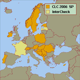
CLC2006 software was distributed by MLOG Instruments Ltd., Budapest, Hungary. In the European CLC2006 project 17 European national teams used this software (see figure). Further two countries purchased licenses only of the InterCheck program, the control part of the package. InterCheck program has been prepared primarily for supporting the CLC2006 Technical Team, although national central teams might also use it as a tool for final checking of the completed CLC2006 and CLC-Change databases.
CLC2006 checking procedure was done in all 38 participating countries with help of the InterCheck software, because it can be used for checking CLC2006 and CLC-Change databases in any file format that can be added to ArcView program as a theme (ESRI shapefile, ARC/INFO coverage, AutoCAD drawing etc.), i.e. not only those that has been prepared with InterChange.
|
|
CLC2006 software legal users
- Albania,
- Austria,
- Bosnia,
- Croatia,
- Cyprus,
- Estonia,
- France (InterCheck only),
- Hungary,
- Ireland,
- Latvia (InterCheck only),
- Luxemburg,
- Montenegro,
- Norway,
- Poland,
- Portugal,
- Romania,
- Serbia,
- Sweden,
- Switzerland.
LUCAS data
LUCAS (Land Use/Cover Area frame statistical Survey) is co-ordinated by the Statistical Office of the European Commission (Eurostat). Land cover refers to the bio-physical coverage of land (e.g. crops, grass, broad-leaved forest, or build-up area). Land use indicates the socio-economic use of land (e.g. agriculture, forestry, recreation or residential use). LUCAS land use/cover data are used among others to calculate Sustainable Development Indicators, Land take and Agro Environmental Indicators to support spatial planning in Europe.
|
|
CLC2000 Support Package
| |
|
CLC2000 Support Package has been developed for Remote Sensing Centre of Hungarian Institute of Geodesy, Cartography and Remote Sensing (FÖMI), in order to help the implementation of the European CLC2000 project managed jointly by the European Environment Agency (EEA) and Joint Research Centre (JRC). The software operates under ArcView environment. ArcView software is designed primarily for viewing GIS databases with tools for creating maps, menus for handling databases and graphical editing tools. At the same time, ArcView includes only limited and less effective tools for creating and filling new polygon databases or modifying existing polygon databases. As a solution, CLC2000 software under ArcView provided a cheap tool for quick and comfortable editing and handling of CORINE Land Cover databases.
CLC2000 software was a macro package written in Avenue, ArcView's own macro language. The software was a supplement to ArcView 3.2/3.3 GIS. The use of the CLC2000 Support Package significantly facilitated updating, change detection, quality control and correction of land cover databases by means of computer-assisted visual photo-interpretation. The CLC2000 software was used by 15 European national teams, out of 30 participating countries for interpreting changes in CLC2000 project.
|
|
Avenue
Avenue is an object oriented scripting language and development environment
fully integrated with ESRI ArcView GIS software. With help of Avenue user
can freely customize the user interface of ArcView, and can create complete
applications for specific GIS tasks. Unfortunately ArcView came outdated.
Last version 3.3 released in 2002, and since 2005 ESRI provides only limited
support for this product. Recent ESRI software ArcGIS uses Visual Basic as
built-in scripting language.
|
|
|
